(c) Copyright administered by New Tribes Mission, Australia
|
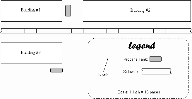
One of the quickest ways to get acquainted with the physical setting in the tribe is to get a map of the village. A map provides an early opportunity establish ourselves in a learners role. It can be done with the little language you have been learning, since about all you need to do is explain what you are doing to the villagers and perhaps obtain permission to do it. The people may not fully understand what you are doing, but as they become aware of what the map is it often becomes a point of discussion among them. When I did mine in Panama, almost everyone in the village came to see it. Many wanted me to do one for them. As they would come over to look at it, I had opportunity to use some simple phrases to find out which house they lived in and I quickly became familiar with both the village setting and many faces and names. The purpose of the map is NOT extreme accuracy. It serves as a means of acquainting ourselves with the "stage" on which much of the way of life will be played out. There are certainly more accurate methods of mapping than the one we will present here, and probably some that are even simpler, but this one has proven effective. (A similar method of measuring was used with fatal accuracy during the Vietnam war by Viet Cong to measure distances for mortar fire.) All you need is your field notebook, a pencil with an eraser, and a ruler. Here's how it works: On a clean page of your field notes, mark off four columns... |
|
From |
Paces |
Direction |
To |
|
SE corner bldg #1 |
8 |
North |
NE corner #1 |
|
NE corner bldg #1 |
32 |
West |
NW corner #1 |
|
NW corner bldg #1 |
8 |
South |
SW corner #1 |
|
SW corner bldg #1 |
24 |
West |
SE corner #2 |
|
SE corner bldg #2 |
8 |
North |
NE corner #2 |
|
NE corner bldg #2 |
24 |
West |
NW corner #2 |
|
Pick a point of reference from which you will pace off the distances to the various buildings on your map. You then simply pace in straight lines and at right angles, noting down the distances in your field notes as you go. |
|
NW corner bldg #2 |
12 |
North |
sidewalk (1 pace wide) |
|
sidewalk |
12 |
North |
SW corner #3 |
|
SW corner bldg #3 |
24 |
East |
SE corner #3 |
|
SE corner #3 |
8 |
North |
NE corner #3 |
|
Having determined that building #2 is rectangular, we only need to measure the length of two sides. We can now measure the distance from it to the sidewalk. Using variations of technique, trees, trails, special buildings, etc. can be included on the map. When the entire area to be mapped has been measured you can simply reverse the process and transfer the data to a piece of paper. Using a ruler you can reproduce the measurements with a scale of 1 inch = 16 paces (1/16 in./pace) or 1 centimeter = 10 paces. Transfer the data to the map in the same order you paced it off. If you get confused, you can always go out and pace through that part again. Here is what the above information would look like if transferred to a map. |
|
Of course there are often situations where because of great distances this method of mapping will not work. In such cases you can often use detailed maps already available through other sources. Make use of them and simply mark on them where the houses are. Remember, the purpose of mapping is to familiarize yourself with the "where" of the culture. |